A powerful winter storm is on the way and expected to impact Hopewell Valley and much of New Jersey from late Saturday night through Monday, bringing heavy snow, sleet, and periods of freezing rain that forecasters warn could make travel dangerous or impossible.
In its latest briefing issued Saturday afternoon, the National Weather Service said confidence is high that the region will see major impacts, with widespread snow and sleet accumulations followed by a transition to freezing rain in parts of central and southern New Jersey. A Winter Storm Warning remains in effect through early Monday afternoon.
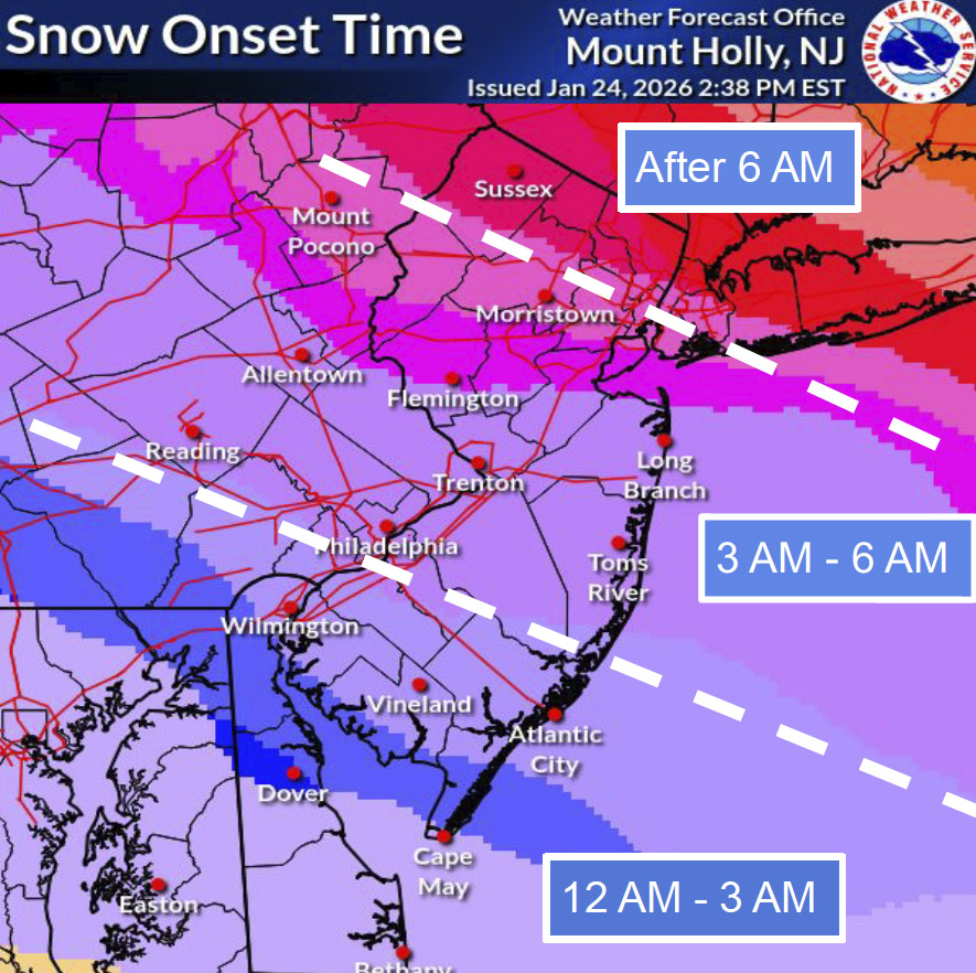
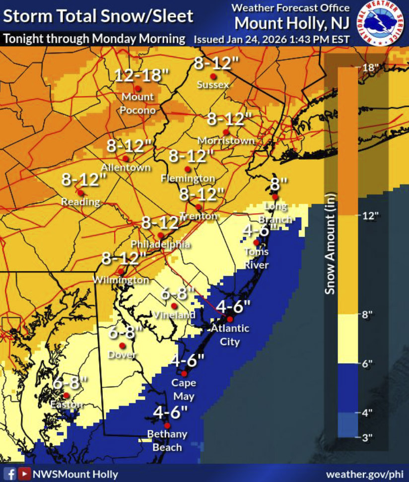
Forecasters said snow is expected to begin late Saturday night and intensify early Sunday morning, with snowfall rates potentially reaching 1 to 2 inches per hour during the day Sunday. Across central New Jersey, including Mercer County, total snow and sleet accumulations of 7 to 10 inches are likely, with additional ice accretion possible Sunday afternoon and evening as precipitation mixes with freezing rain.
The combination of snow, sleet, ice, and gusty northeast winds could lead to hazardous road conditions, widespread closures, and isolated power outages, particularly along the Interstate 95 corridor and into central New Jersey. The National Weather Service emphasized that while snowfall totals have been adjusted slightly downward, overall impacts remain unchanged due to the expected wintry mix and prolonged cold that will follow the storm.
State of Emergency Measures and Travel Restrictions
In response to the forecast, New Jersey has enacted a statewide emergency response aimed at keeping roads clear and reducing the risk of accidents.
Beginning at 12:01 a.m. Sunday, the New Jersey Department of Transportation temporarily lowered speed limits to 35 miles per hour on all Interstate and state highways, including the New Jersey Turnpike, Garden State Parkway, and Atlantic City Expressway. The order will remain in effect until conditions improve.
NJDOT has also issued commercial vehicle travel restrictions on multiple Interstate highways statewide, while urging all motorists to avoid unnecessary travel through Monday. Officials warned that plowing and emergency response operations depend on keeping roadways clear.
NJ TRANSIT announced a systemwide suspension of bus, light rail, and Access Link service starting at 4 a.m. Sunday, with rail service operating on a limited schedule until 2 p.m. Sunday, after which all rail service will also be suspended. Service will resume only when conditions safely allow.
Local Impacts and Reminders in Hopewell Valley
Local municipalities across Hopewell Valley are urging residents to prepare now and stay off the roads once snow begins.
In Hopewell Township, parking on municipal roads is prohibited once two or more inches of snow have accumulated. Residents are also asked to remove basketball hoops, trash cans, hockey goals, and other equipment from roadways to prevent damage to both property and plow trucks.
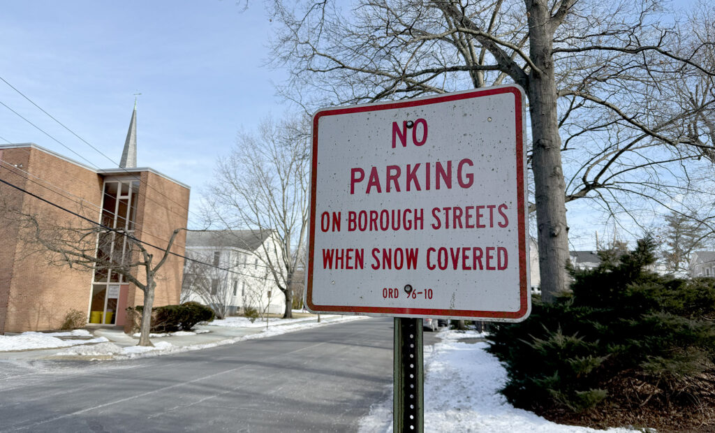
Hopewell Borough and Pennington Borough have both issued snow emergency reminders emphasizing that vehicles must be removed from snow-covered streets to allow Public Works crews and emergency responders to operate. Snow emergency parking will be available at designated municipal lots, while parking on roadways during snow events will be enforced.
Officials also warned that freezing rain and ice following the snowfall could lead to downed power lines and outages. Residents are urged to treat all downed wires as live and report outages to immediately. Warming centers will be available if power or heat is lost, including at the Hopewell Township municipal building.
Dangerous Cold to Follow
Beyond the storm itself, forecasters are warning of a prolonged stretch of dangerous cold lasting through much of next week. Daytime temperatures are expected to remain in the teens and 20s, with nighttime lows dropping into the single digits or below zero. Wind chills could fall between –10 and 0 degrees, increasing the risk of frostbite and hypothermia with prolonged exposure.
Officials urge residents to prepare for extended winter conditions by securing essential supplies, checking heating systems, and limiting travel whenever possible.
Additional updates from the National Weather Service are expected early Sunday morning as the storm continues to develop.