A major winter storm expected to arrive this weekend could bring the most significant snowfall the region has seen in years, with forecasters warning of dangerous travel conditions, prolonged cold, and widespread impacts across New Jersey, including the Hopewell Valley.
Editor’s note this story was updated at 8:25 a.m. with updated information from the National Weather Service.
In a briefing updated Friday morning, the National Weather Service said confidence continues to increase in a powerful winter storm expected to affect central New Jersey from Saturday night through early Monday, bringing a combination of heavy snow, sleet, and freezing rain. Forecasters warned that while snowfall totals may trend toward the middle of projected ranges due to mixing, the storm is still expected to create hazardous travel conditions, with ice accumulation and prolonged cold increasing the risk of power outages and extended disruptions.
The National Weather Service said additional forecast updates and refined snowfall and ice projections are expected later Friday as the storm track and precipitation types continue to come into sharper focus. The expansive winter system is expected to impact a wide swath of the country as it moves east from Texas toward the Mid-Atlantic and Northeast.
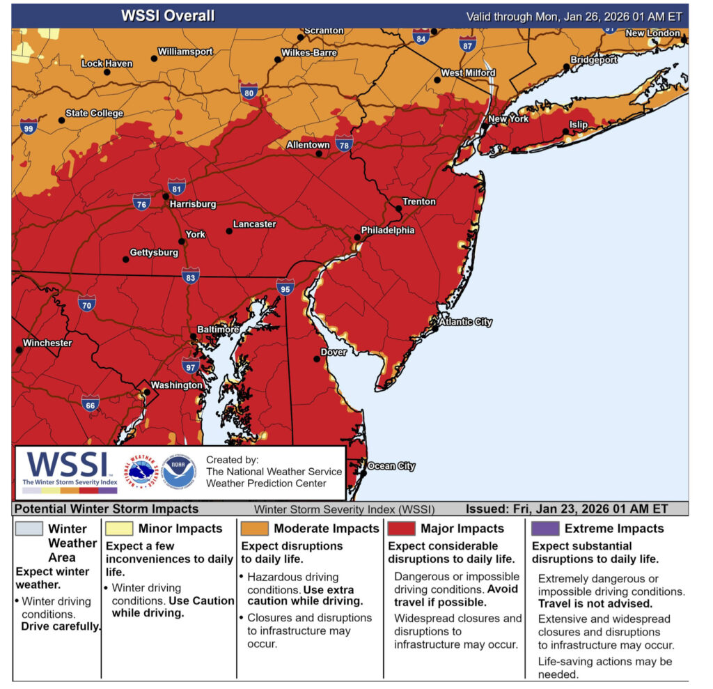
Forecasters also cautioned that ice accumulation, gusty winds, and an extended period of bitter cold following the storm could significantly worsen impacts, with conditions deteriorating again overnight as temperatures plunge. The National Weather Service’s Winter Storm Severity Index now indicates the potential for major impacts across much of New Jersey, including dangerous or impassable travel, scattered power outages, and a slower-than-usual cleanup as subfreezing temperatures persist into next week.
Township Prepares for Prolonged Snow Event
Ahead of the storm, Hopewell Township’s Public Works Department has been preparing for what could be an extended snow response.
According to Public Works Director George Snyder, crews have inspected plows and salt spreaders, replaced worn equipment, and held internal briefings to review storm priorities, route assignments, and safety procedures. Trucks will be staged and ready to deploy once conditions warrant, with plowing operations typically beginning after about two inches of snow have accumulated.
Depending on the severity of the storm, Snyder said plowing and cleanup operations may continue for up to a full day after snowfall ends, particularly with very cold temperatures expected to follow.
Parking Restrictions and Safety Reminders

The township also issued a reminder to residents that local ordinances prohibit parking on municipal roads once two or more inches of snow have accumulated. Vehicles left on roadways can interfere with plowing operations and delay snow removal.
Residents are also asked to remove items from the roadway that could be damaged by plows or pose a hazard to crews, including basketball hoops, hockey goals, skateboard ramps, trash cans, and other athletic or household equipment.
Officials are encouraging residents to prepare ahead of the storm by gathering essential supplies and to stay off the roads whenever possible during and immediately after the snowfall. Clear roadways allow Public Works crews to operate more safely and efficiently, speeding up overall recovery.
With dangerously cold temperatures expected to follow the storm, residents are also urged to limit time outdoors, check on neighbors who may need assistance, and take steps to protect pets, pipes, and heating systems.
This story will be updated as additional advisories and forecast information are issued Friday morning.